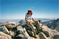
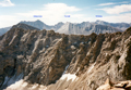
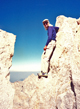
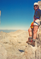
This was an eight-day CMC peak climbing trip with a small but fine group: Rick Beatty, Larry Hoak and Reiner Stenzel. Due to nearly perfect weather conditions we climbed as much as we could: ten SPS peaks, half of them mountaineers peaks. The SMS has skied near the Great Western Divide and it is nice to see the region in two different seasons. Here is our summer climbing adventure:
 SATURDAY, 7/28: After obtaining a wilderness permit at Lone Pine we drove to the Shepherd Pass trailhead, encountered some confusion with the two separate trailheads (stock vs. hikers), resulting in a late start (10am) on a warm day. After the four stream crossings of Symmes Creek there was no water on the trail till Mahogany flats. We reached Anvil Camp by 4:30pm and decided to stay.
 SUNDAY: Rick and Reiner left at 5:30am for Shepherd Pass. deposited the packs at Lake 12,002', secured the food from marmots and headed up to Junction Peak. We ascended the South slopes of Diamond Mesa, followed along a knife-edge ridge to Junction and reached the summit at 10:30am. (RB In climbing the peak, we followed the ridge between Diamond Mesa and the Peak until the mountain and then went right (Southeast) and up the ridge on easy but somewhat sustained cl. 3 rock until reaching the area where the summit is visible. From there it was a mixture of cl. 2 and cl. 3 to the summit.)
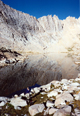
 We returned via some cl. 2 ledges along the West side well below the ridge to the saddle between Diamond Mesa and Junction, descended on scree slopes to Lake 12,460', and returned to Shepherd Pass by 12:30pm. In the afternoon we proceeded to Lake South America, which was reached by 5:30pm. Larry who had arrived earlier found an excellent campsite at a small lake (RB No trout in this lake, but the water was comparatively warm for bathing.) 1/4 mi. SE of Lake S. America where we stayed for two nights.
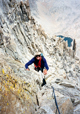
 MONDAY: We left at dawn (5:30am) to climb Stanford and Ericsson. Heading North toward Harrison Pass we ascended Gregory's Monument, which was reached by 7:30. (RB We never did find the reported use trail from Harrison Pass to Gregory's Monument.) to continue to the North Summit of Stanford, we climbed over Gregory Peak and after about 30' descended with belays into a notch from which a ledge system starts along the East face. (RB The belay was used for a downclimbing step across.) The ledge is rather exposed. (RB In places the ledge was exposed, outward-sloping, gritty, contains some loose rock or without good handholds. We just took it slow.)
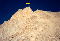
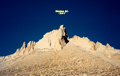
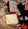 It starts out about 30' below the ridge, at halfway it drops through a narrow gully to about 100' below the ridge, and finally it arrives at a sandy saddle between a large single arete East of the summit and a scree filled gully leading toward the summit. (RB The summit is the left most of the two high points visible. Some switchbacks are just before the gully.) After ascending the gully and continuing North on cl. 3 rocks we reached the summit at 9:30am. We were rewarded by a great surprise: an Original peak register from 1898 with historic signatures by Bolton-Brown, Clyde, LeConte, Brewer, etc. Only 3-4 parties climbed this peak annually. We carefully retraced our route that we had marked with ducks and climbed down to Harrison Pass where we had lunch with Larry at 12:30pm.
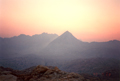
 In the afternoon we ascended Mt. Ericsson via the Northeast slope. We followed a large gully into a narrow notch in the ridge, crossed over and downclimbed about 50' on the West side where we found an easy chute leading up to the Northern named peak. The summit was reached via cl. 3 rocks. Unfortunately, the view from the summit was poor due to the rising smoke clouds from forest fires in Kings Canyon NP. We descended on the West face toward Lucy's Foot Pass, then returned XC to our basecamp by 4:30pm.
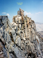
 TUESDAY: We got up at 4:15am, broke camp and headed one mi. South on the Kern Valley trail to an unnamed Lake 11,280' (RB That lake was packed with trout. I watched a fisherman pull in an 8" trout on his second cast.) to set up a basecamp for Jordan and Genevra. Larry decided to head back early and bid us farewell. After securing our food in trees we left for Mt. Jordan at 7:30. We ascended a gully on the East face, turned left (South) about 100' below the notch, and encircled the Southern peak on duck-marked
ledges. We found the cl. 4 summit block which is reached after a four foot "airy traverse" ( RB I remember it as a three foot step across from a flat shelf with one handhold to a slope. It slopes toward you as you are standing on the flat shelf.) with seven to ten feet of exposure on the left and perhaps 100 feet on the right. The third move after the step across is an easy layback using a crack and then two moves farther is a fixed pin to clip in.
TUESDAY: We got up at 4:15am, broke camp and headed one mi. South on the Kern Valley trail to an unnamed Lake 11,280' (RB That lake was packed with trout. I watched a fisherman pull in an 8" trout on his second cast.) to set up a basecamp for Jordan and Genevra. Larry decided to head back early and bid us farewell. After securing our food in trees we left for Mt. Jordan at 7:30. We ascended a gully on the East face, turned left (South) about 100' below the notch, and encircled the Southern peak on duck-marked
ledges. We found the cl. 4 summit block which is reached after a four foot "airy traverse" ( RB I remember it as a three foot step across from a flat shelf with one handhold to a slope. It slopes toward you as you are standing on the flat shelf.) with seven to ten feet of exposure on the left and perhaps 100 feet on the right. The third move after the step across is an easy layback using a crack and then two moves farther is a fixed pin to clip in.
 Another four or five moves along the layback brings you to the flat summit area.) between two exposed blocks for which we used top belays. After signing the register at 10am we rappelled down and reversed our steps. After lunch near the small lake between Jordan and Genevra we ascended at 12 noon the West slopes of Genevra that lead without surprises to the summit. Lack of view due to smoke drove us down the Southeastern slopes toward our basecamp where we arrived at 3pm. ( RB The Southeastern slopes involved some mildly exposed cl. 2 face and a little cl. 3 downclimbing.)
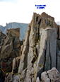
 WEDNESDAY: Another 4:30am rise got us off to an early start for Thunder Mtn. We headed West through a broad beautiful valley with streams and frosty meadows toward Lake 12,280' Southeast of Thunder, Northeast of Table. We ascended at 8:30am the Southeast talus slopes of Thunder to reach the South summit at 9: 15am. (RB The easiest way past the South summit is to climb over the top of it.) We set up a belay to downclimb on the North side toward a gully, which is crossed via a rock bridge. On exposed ledges (cl. 3-4) we headed toward the North summit. The cl. 4 summit wall was climbed at 11am via a chock stone in a small chimney. (RB I found this to be the most interesting and fun climbing of the trip. The summit block is height dependent and is easy if you are taller than 6'.)
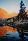
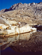
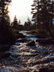
 The 50-year old summit register listed many historic climbs. After enjoying a great view we carefully downclimbed along the same route, descended to Lake 12,280' where we had lunch at 1:30pm, and returned from this very satisfying climb to basecamp at 4:30pm. After a short swim and rest we packed up and headed South toward the Kern River and Milestone Creek. At 6:30pm we set up camp in the beautiful Milestone Creek drainage. A deer grazed near our campsite. Because of the reported resident bears we hung our food high in a tree. Mosquitoes were abundant. (RB Milestone Creek and its lakes are just packed with trout and the upper part of the stream is lined with wildflowers)
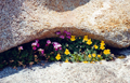
 THURSDAY: At 5:50am we headed up Milestone Creek toward Table Mtn. We climbed to an unnamed Lake 11,900' East of Midway, South of Table, then ascended the Southeast scree slopes of table aiming at a V-notch in the skyline. The brown ledge in the middle of the Southern escarpment leading diagonally up toward the upper right as described by Roper (Route #3) is clearly visible. The goal is to get to its lower left (SE) end that is not straightforward. A duck-marked ledge leads initially away (SW) from the ledge, then works upward, turns back and down toward the start of the brown ledge. Following the ledge leads to an arete where one turns left and up a chute with lots of loose rocks. En route there is a key hole to crawl through. Then it is easy scrambling to the flat summit plateau.
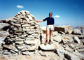
 It is wise to build/rebuild cairns on the way up since alternative routes are mostly cl. 4. The 50-year old peak register is at the North end of the plateau under a 6 foot cairn. At 10am we retraced our route appreciating the value of good duck marks. We ate lunch at a small lake between Table and Midway, then at 12:30 ascended a saddle in the East ridge of Midway and scrambled up the cl. 2 ridge to the summit. At 2pm the smoke from forest fires filled the air again. Thunderstorm clouds grew everywhere. We descended toward Milestone Creek and reached basecamp at 4:30pm just before a heavy thunderstorm came down with rain, hail and nearby lightning. After it cleared the evening was superb.
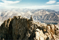
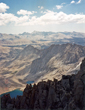
 FRIDAY: At 5:30am we were en route to Milestone Mtn. Up Milestone Creek and the East scree slopes of Milestone we headed into the notch to the right (North) of the summit block. Descending about 100' on the West side, we ascended the cl. 3 West ridge and reached the summit at 8:30am. A splendid view on a cloudless, smokeless day was the reward for the ascent of Milestone. Reiner inspected carefully Milestone Pass and Bowl which forms part of the Sierra High Route for ski mountaineers. (RB Robin Registertheif had been to this peak and the register was less than a year old.
 It contains several comments about register thieves and their ancestry.) At 9am we returned, ate lunch at noon at the basecamp, packed out and hiked back to Shepherd Pass Lake (12,002') where we arrived at 5pm. We met an SPS group (Don Borad, Phil Marquez) who were aiming for Junction and Tyndall over the weekend.
SATURDAY: Out of habit we got up at 4:30am. Reiner climbed Tyndall. (RB started down at 6:00 and reached the trailhead at 11:45). The shortest ascent was to climb up a rock ledge on the North face and to follow the cl. 3 ridge to the summit, which was reached at 7am. From then on it was all down hill, 8,400' down to Symmes Creek Trailhead (5,600'). At 4:30pm we changed into clean clothes and drove off into the desert heat.
 In retrospect, a week's trip with ten peaks climbed can be considered quite successful. The trip went well partly because the weather was on our side but mainly because of a skilled and spirited climbing partner. Thanks a lot, Rick. (RB A major contribution to the success of the trip was Reiner's careful navigation and routefinding.)
Back to Trip Reports
Back to SMS Home Page